
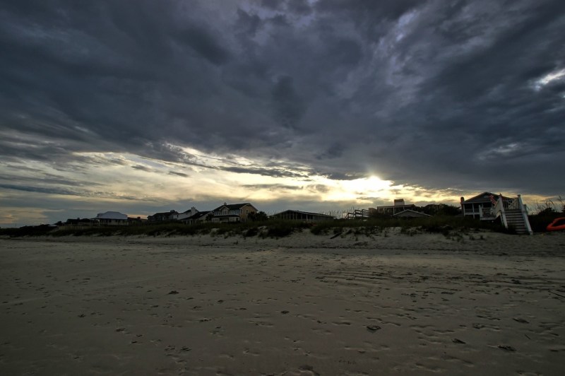
Featured Image Credit: Forsaken Fotos via Visual Hunt / CC BY
Introduction
I have people I care about who’ve been involved in each of the devastating hurricanes recently beginning with Harvey. Slowly overtime I’ve built up a small collection of useful tools for getting first hand information that I decided to share. In addition, currently in the ios App Store if you look under the ‘Featured’ section you’ll find a helpful listing of apps Apple deems useful to people who are anticipating that a hurricane will cross their path. So without further adieu…
Finding Recommended Apps from Apple’s ios App Store
It’s very easy to find the app collection that Apple has designated useful during this years hurricane season. Just open the App Store on any ios device and tap on the Featured category on the bottom menu. When you do so you’ll immediately see this collection of apps on the top line of recommended apps.

Weather Tools
Windy App Free
Provides wind and waves forecast by Windyty, SE
Tap or click on each image below to enlarge it:
-
- When you open the Windy app this is what you see
-

- The Windy App in the ios App Store
-

- The time Irma will hit this site in Florida
-

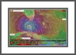
- Windy’s radar forecast
-

- Weather forecast comparison using 4 popular forecasting standards
-

- 3 day rainfall forecast
Windy’s Browser Alternative
Both tools are the same and pretty amazing…well I can only speak for the ios app really, which is pretty amazing. Not only can you see great visuals for wind speeds but you can see forecasts by 3-5 different forecasting services and determine 28 different variables for locations you zero in on. You can also save the locations you’re interested in tracking and even have customized weather alerts for those locations sent to yourself.
WNYC Hurricane Tracking Map
This browser based tool lets you see exactly where hurricanes are at any given moment in time.

An example using WYNC in Safari to find Irma’s current location
Hurricane App by American Red Cross Free
-

- This is what the Hurricane by American Red Cross app looks like in the App Store.
-

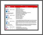
- An overview of all the warnings for one site in Florida
-

- The opening screenshots of the app
-
- The American Red Cross Hurricane warning for one portion of Florida
Communication
FireChat App Free

A description for FireChat’s features in the app store
FireChat is an amazing instant messaging tool if/when it works for communications during disasters. It allows users to create their own mesh networks based solely on Bluetooth without needing to use WiFi or cellular networks. Bluetooth generally works at distances of up to about 300 feet or 100 meters.
The technology is complex and I don’t begin to understand it, but through the use of people who’ve joined a group network, it’s even able to connect greater distance if someone in the smaller network has WiFi connectivity. But all this is predicated upon if it works at all. When it does it’s supposed to be amazing…when it doesn’t it’s apparently useless. Here’s a link to FireChat’s website to learn more.

FireChat’s Website
If FireChat doesn’t work for you a website calling themselves Gecko and Fly wrote a helpful article about 4 others that utilize the Bluetooth mesh networking technology too. I could be wrong, but I believe that FireChat was the first to offer this cutting edge technology.
This video describes how FireChat works:
Live Streamed Video
Aside from YouTube, there’s another live streaming website that I’ve found to be invaluable during this most recent set of hurricanes. It’s an app called Periscope that is owned by Twitter. I’m sharing this with a bit of trepidation after a friend tried it based upon my recommendation and immediately encountered porn. Personally, I’ve never encountered porn on Periscope…but then I’ve only used it a few times. When I did I only sought hurricane footage…ideally live streamed videos of the weather’s impact in areas where someone I was worried about resides.
You need to either setup an account with Periscope or login through Twitter. Because I think my search method is pretty safe I’ll describe it. The way that I use Periscope is to look on the bottom menu for a globe icon. I tap on that to pull up a map of North America and then drag the map around using pinch and zoom gestures until I find a livestream I want to view. You can identify active live streams by looking for the red circles. If there are no red circles, then I look for blue circles. Those are very recent live streams. In hurricane areas that are just beginning to be hit, you can usually find a few people who are broadcasting right before and during the early portions of the hurricane. But once it’s progressed the area may lose power in which case these live streams usually end.
Periscope App Free
Live Video Streaming Around the World by Twitter, Inc.

Features of Twitter’s Periscope App
Comments
If you’d like to read other’s comments, (assuming there are any,) leave a comment yourself, or ask a question, please do so by scrolling down.
